自然保护与休闲部
保护·守护·共享
自然保护与休闲部


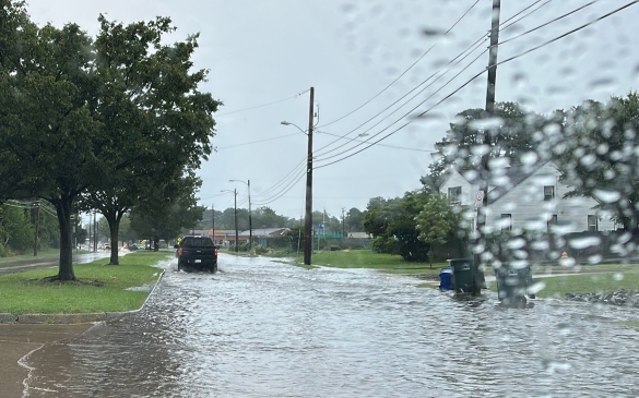
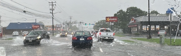
Figure 1. Heavy rainfall flooding roads and neighborhoods in Norfolk, Virginia. Photos courtesy of Dewberry.
When heavy rain hits, flooding can happen fast. A street turns into a stream. A parking lot fills up. Water reaches homes and businesses far from any river or coastline.
For years, many Virginians have dealt with this kind of flooding without clear maps to show where the risk exists. Now, the Virginia Department of Conservation and Recreation (DCR) is changing that.
DCR recently completed one of the largest rainfall-driven flood modeling efforts in the country, creating new tools that show where intense rain can cause flooding across Virginia. The project closes a longstanding gap in flood-risk data and gives communities new information to plan, prepare and invest more wisely.
The effort has also drawn recognition from the engineering community. In 2026, the project earned the Grand Award and Pinnacle Award from the American Council of Engineering Companies of Virginia (ACEC Virginia) as part of its Engineering Excellence Awards program. The awards recognize projects that demonstrate exceptional innovation, technical achievement and public benefit.
“This work … empowers communities to make smarter infrastructure investments, enhance emergency preparedness, and protect lives and property in an era of increasingly intense storms,” said Chris Stone, a member of ACEC Virginia’s Emeritus Judging Panel. “It is an extraordinary example of engineering ingenuity applied directly to safeguarding the public and strengthening long-term resilience across the commonwealth.”
Flooding has been happening in places that were never shown on the map.
Many know about Federal Emergency Management Agency (FEMA) flood maps, called Flood Insurance Rate Maps, or FIRMs. These maps help show risk from river and coastal flooding and play an important role in insurance and development decisions. But they generally do not show rainfall-driven flooding, also known as pluvial flooding, which happens when heavy rain overwhelms natural or built drainage systems, leading to stormwater flooding and ponding.
The lack of rainfall-driven flood data has left communities without critical information about a hazard they face regularly. National studies suggest that more than 40% of flood losses occur outside FEMA-mapped flood zones. During development of Phase I of Virginia’s Coastal Resilience Master Plan, the commonwealth’s long-term strategy for addressing flood risk, local officials repeatedly identified rainfall-driven flooding as one of their top concerns.
DCR responded by developing better flood-risk information for communities.
The scope of the modeling effort reflects both its ambition and its urgency:
These numbers represent more than scale. They reflect a focused, statewide effort to deliver actionable information to communities as quickly as possible.
From the start, DCR designed the modeling framework to remain useful over time. DCR convened a technical advisory committee with state agency staff and university partners to provide input on the methodology and ultimately created an “evergreen” approach so the work can remain useful as rainfall science advances and national standards evolve. In practical terms, this means the models are not locked into today’s rainfall assumptions. As NOAA updates guidance on how often and how intensely rain falls, the same models can be easily connected to new standards — keeping flood information current without starting over.
The project produced reusable, two-dimensional flood models that local governments, researchers and practitioners can download, rerun and adapt for their own needs. The data follows FAIR principles — findable, accessible, interoperable and reusable.
Today, flood hazard extents, depth grids and impact data are available to the public through the Coastal Resilience Web Explorer and the Flood Resilience Open Data Portal. A Pluvial Model Catalog and Use Case Guide also help communities put the information to work.
For communities across Virginia, the benefits are practical and immediate. Local planners can better see which roads, buildings, and neighborhoods are vulnerable to severe rainfall impacts. Engineers can design smarter drainage improvements. Emergency managers can plan response and evacuation routes with more complete information. Residents can better understand why flooding may occur in areas not shown on traditional flood maps.
In short, the work is both a technical achievement and a practical one: advanced modeling built to help communities make smarter decisions before the next storm hits. With the closing of this long-standing flood data gap, communities now have better tools to prepare, invest wisely and reduce risk today and into the future.